related blog
%20(3).svg)
8
How GPS-Tagged Photos Enhance Real-Time Updates
GPS-tagged photos provide verified location and timestamps, automate filing, enable live updates, and reduce disputes for construction teams.

GPS-tagged photos are transforming how teams manage projects by providing real-time, location-based updates. These images automatically include precise location and timestamp data, ensuring accuracy and eliminating manual entry errors. Here’s why they’re a game-changer:
- Real-Time Monitoring: Photos sync to cloud platforms, allowing supervisors to track progress instantly, without being on-site.
- Improved Accuracy: Embedded GPS data confirms where and when the photo was taken, reducing fraud and errors.
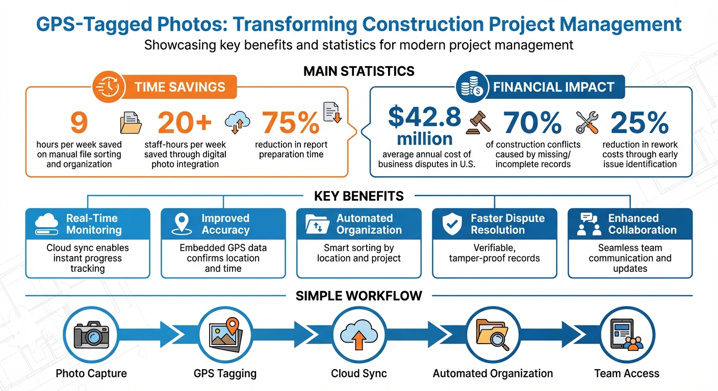
- Simplified File Management: Automated sorting by location and project saves up to 9 hours per week in manual work.
- Faster Dispute Resolution: Verifiable records help prevent costly disputes, which account for 70% of construction conflicts.
- Enhanced Collaboration: Teams share updates effortlessly, speeding up communication and payment cycles.
Tools like CrewCam take it further by offering offline capture, live feeds, and one-click reports, making GPS-tagged photos a reliable solution for improving workflows and reducing risks.
GPS-Tagged Photos Impact on Construction Efficiency and Cost Savings
How GPS Metadata Improves Accuracy and Organization
Location-Based Documentation
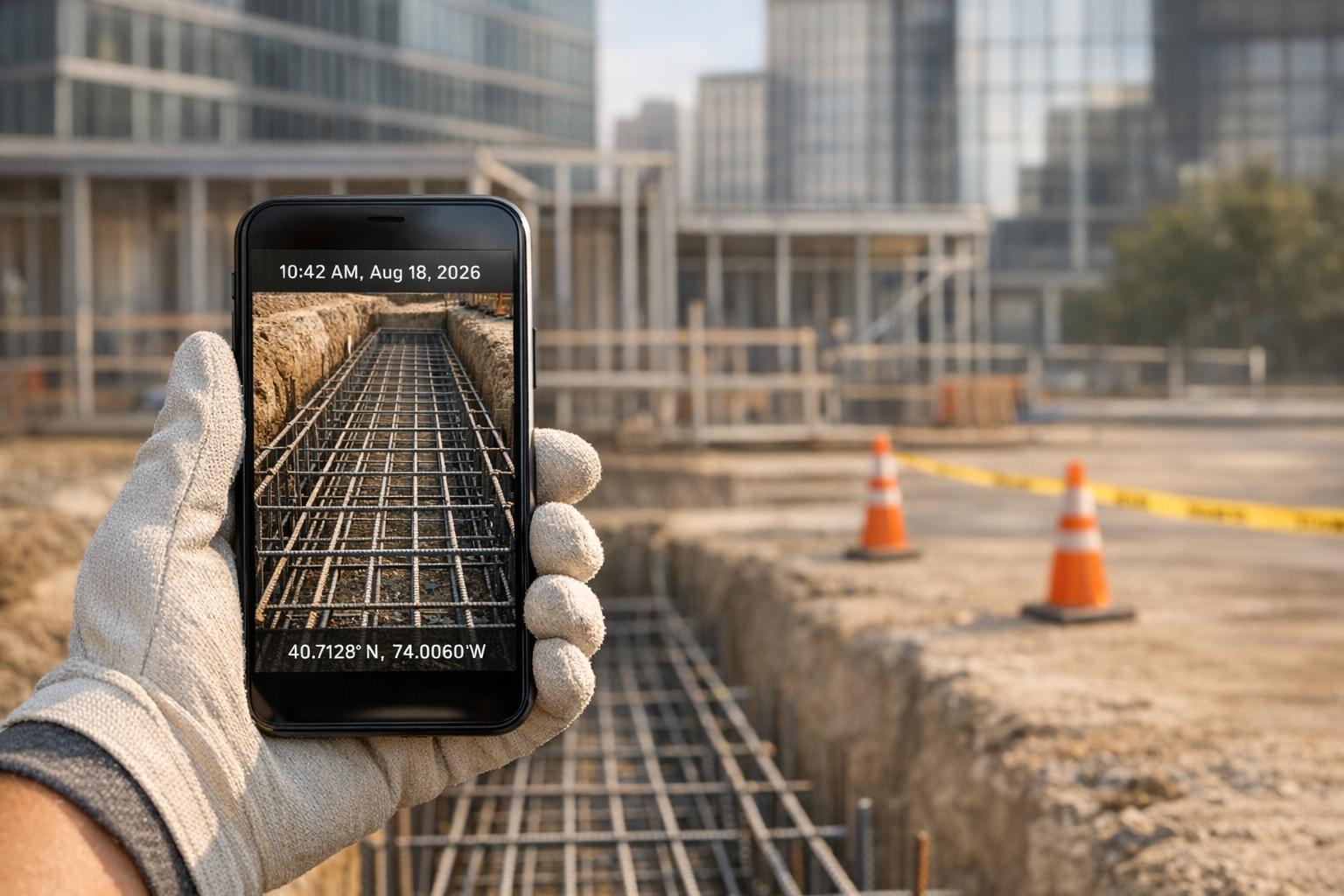
GPS metadata adds a new layer of precision to job site photos, turning them into verifiable records by embedding latitude and longitude coordinates into the image's EXIF (Exchangeable Image File Format) data. This process happens automatically as the photo is taken, ensuring that the image captures the exact location and time without requiring any extra effort from field workers.
These embedded coordinates do more than just confirm a photo's origin. Many modern platforms use GPS data to place photos as pins on interactive site maps, giving project managers a bird's-eye view of progress across specific areas or tasks. This visual tool makes it simple to see which parts of a project have been documented and which still need attention. Additionally, this system helps prevent fraudulent submissions by providing location-based evidence for every photo.
The accuracy of GPS metadata also serves as a natural safeguard against fraud. If someone attempts to submit an old photo or an image from an unrelated project site, mismatched location or time data will raise immediate red flags. For construction teams juggling multiple sites, this verification capability is invaluable. It ensures crews are where they need to be and that all documentation reflects actual on-site conditions.
Automated Organization for Project Files
GPS-tagged photos take the hassle out of file management. Project management tools can automatically sort images by project, job site, or crew, removing the need for manual organization. This automation can save teams a significant amount of time - using standard phone cameras for documentation often wastes up to 9 hours per week on manual sorting.
The benefits of this automation go beyond just saving time. Once photos are uploaded to a centralized cloud database, they become instantly accessible to office teams. Managers can quickly search for images by date, location, or project details. Many platforms even offer one-click report generation, allowing users to create polished PDF or Excel reports directly from the organized metadata. Industry data shows that integrating digital photo processes can save contractors over 20 staff-hours per week, while digital tools can cut report preparation time by 75%.
Platforms like CrewCam take this further with features like project-specific checklists and photo tags that complement GPS metadata. Field teams can capture high-quality images with automatic location stamps, even in offline mode, and the system syncs everything to the cloud once they're back online. This ensures every photo is properly documented and easily accessible through desktop or mobile apps. By automating organization, these tools also pave the way for smoother communication through real-time project updates.
sbb-itb-5f4c686
Benefits for Team Collaboration and Communication
Smoother Team Coordination with Visual Evidence
GPS-tagged photos take the guesswork out of construction projects. When field teams capture images with precise location data and include on-photo annotations - like typed notes, weather details, or task-specific information - it bridges the communication gap between the office and the job site. This level of clarity eliminates the need for long email threads or endless phone calls, making workflows more efficient and keeping everyone on the same page.
Having visual evidence also speeds up payment processes and reduces disputes. Subcontractors can share GPS-tagged photos of completed work with general contractors instantly, ensuring transparency and accelerating payment cycles.
With CrewCam's annotation tools, teams can mark up photos directly, add text, and leave comments tied to specific images. This ensures that important context stays intact when the photos are reviewed at the office. By providing clear, construction photo documentation, misunderstandings between crews, managers, and clients are minimized, giving everyone a shared, accurate view of the project.
Real-Time Updates with Live Project Feeds
Beyond annotated visuals, real-time updates through live feeds take project management to the next level. Live project feeds let supervisors keep an eye on progress remotely, confirming that teams are working in the right locations and sticking to the plan. This immediate visibility allows managers to address issues on the spot and reallocate resources as needed, preventing small problems from turning into major setbacks.
CrewCam’s live project feed and shareable photo gallery links make it easy to keep everyone informed. Project managers can invite collaborators or share updates externally with just a link, giving stakeholders browser-based access to progress photos without requiring extra software or accounts. Plus, the platform’s offline mode ensures that crews working in remote areas can still capture GPS-tagged photos and notes. Once they’re back online, everything syncs automatically to the cloud, so no updates are ever missed. This seamless connection between the field and the office keeps tasks on track and prevents delays caused by miscommunication or missed updates.
Increased Accountability and Risk Reduction
Building Trust Through Verifiable Records
GPS-tagged photos offer a tamper-proof way to document project activity, ensuring crews are working in the right location and completing tasks on time. Considering that missing or incomplete records account for roughly 70% of business disputes - costing U.S. businesses an average of $42.8 million annually - this level of accuracy is critical.
Unlike standard cameras, specialized documentation tools maintain data integrity. According to research from the National Institute of Standards and Technology (NIST), metadata like GPS coordinates, dates, and times in standard images can be altered without affecting the image itself. On the other hand, professional documentation apps lock this data as soon as the photo is taken, making it tamper-proof and legally reliable.
CrewCam takes this a step further by securing GPS data at the moment of capture, ensuring each image includes verified location and timestamp details that cannot be edited. This creates a reliable record that can be used to reduce disputes and provide concrete proof of work during safety audits, regulatory inspections, or client reviews. By delivering trustworthy documentation, CrewCam helps establish confidence among stakeholders and reduces the likelihood of future disagreements.
Reducing Liability and Disputes
Accurate documentation doesn’t just build trust - it actively prevents conflicts. For example, capturing "before" photos with verified GPS and time data can protect contractors from false claims about property damage. In one real-world case, GPS-tagged photos confirmed pre-existing damage, clearing the contractor of liability.
This kind of precise documentation can also save money by identifying issues early, cutting rework costs by as much as 25%. In one instance, a contractor facing accusations of schedule delays used a report containing a week’s worth of time-stamped photos to defend their position. The evidence helped safeguard their reputation and ensured they received timely payments.
CrewCam’s unlimited cloud storage ensures every photo is securely archived for quick access during disputes. Teams can document site conditions, track progress, and verify compliance using HD photos with location stamps. These records can be shared instantly through secure links, enabling faster dispute resolution and keeping projects on track without unnecessary delays or expenses.
Case Studies: GPS-Tagged Photos in Action
Managing Multiple Sites More Efficiently: Resolving Disputes with Time-Stamped Documentation
Beyond simplifying site management, time-stamped documentation has proven invaluable in resolving disputes. Take, for instance, a situation where a subcontractor was accused of falling behind schedule by a general contractor. This accusation not only risked delaying payment but also threatened the subcontractor's reputation. However, the subcontractor presented a detailed report featuring a week’s worth of time-stamped photos, each verifying progress at specific locations and times. This indisputable evidence immediately cleared the misunderstanding, ensuring timely payment and preserving the subcontractor's professional standing.
CrewCam’s ability to secure GPS data and timestamps at the moment of capture ensures the records are tamper-proof. This feature provides peace of mind and resolves disputes swiftly, saving time and maintaining trust.
Conclusion
GPS-tagged photos have completely changed how construction teams handle real-time updates. By embedding tamper-proof GPS and timestamp data into images, teams can skip the guesswork and cut down on manual filing - saving up to 9 hours a week on average. Earlier, we highlighted how poor documentation can lead to costly disputes, with businesses losing millions annually due to these gaps.
But it’s not just about saving time. Real-time photo feeds help field and office teams stay on the same page, while map views let managers oversee multiple sites without needing to travel. Plus, having verifiable records on hand can resolve disputes in just days, speeding up what could otherwise be a drawn-out process. These features directly tie into the streamlined workflows we’ve discussed.
With tools like CrewCam, teams get access to a full suite of features: GPS and time-stamped photos, automated project organization, live feeds for instant updates, offline syncing for remote sites, one-click PDF reports, and easy-to-share project links for smoother client communication.
Switching from manual methods to GPS-tagged workflows doesn’t just save time - it builds accountability and trust. Whether you’re managing one jobsite or juggling multiple crews, these tools can turn your camera into a game-changing resource for keeping projects on track.
FAQs
How do GPS-tagged photos help improve project accuracy?
GPS-tagged photos bring a new level of precision to project management by automatically capturing the exact location and timestamp of every image. This feature ensures that each photo reflects on-site authenticity, reducing the risk of errors caused by misplaced or misfiled images. It also creates a reliable visual record that supports real-time updates.
Beyond that, these photos simplify identifying issues and resolving disputes. With clear, verifiable evidence of progress or site conditions at a specific time and place, teams can address concerns more effectively. This accuracy keeps everyone on the same page and boosts the efficiency of overall project management.
How do GPS-tagged photos help resolve disputes effectively?
GPS-tagged photos offer a dependable, location-verified way to visually document work, which can make resolving disputes much faster. By showing exactly where and when a task was completed, they help clear up any confusion and minimize disagreements.
What’s more, these photos hold up in legal situations, making them incredibly useful for addressing claims and reducing liability risks. With precise timestamps and accurate details, they provide all parties with reliable records, simplifying the resolution process from start to finish.
How do GPS-tagged photos improve team communication and collaboration on jobsites?
GPS-tagged photos bring clarity to the table by providing precise details about where and when work is being done. With automatic location and time stamps, supervisors can confidently rely on these updates as accurate, on-site, and timely. This creates a dependable record that supports real-time decision-making without second-guessing.
When shared through a live project feed, these photos ensure everyone - whether it's foremen, project managers, or subcontractors - stays aligned. Teams can add comments, annotations, or even link tasks to specific locations, keeping discussions targeted and actionable. This kind of communication not only cuts down on delays but also speeds up decision-making. Plus, if disputes arise, the time-stamped evidence helps resolve issues much faster.
Related Blog Posts


See CrewCam in action
Start your free trial now by clicking the button below


Wanna chat or demo?
Questions? Concerns? Requests? Talk to a real human

Watch a CrewCam demo now 😎
Short on time, busy, got jobs to do? See how CrewCam works now!